
5.4: Geophysical Hazards
- Page ID
- 3946
\( \newcommand{\vecs}[1]{\overset { \scriptstyle \rightharpoonup} {\mathbf{#1}} } \)
\( \newcommand{\vecd}[1]{\overset{-\!-\!\rightharpoonup}{\vphantom{a}\smash {#1}}} \)
\( \newcommand{\id}{\mathrm{id}}\) \( \newcommand{\Span}{\mathrm{span}}\)
( \newcommand{\kernel}{\mathrm{null}\,}\) \( \newcommand{\range}{\mathrm{range}\,}\)
\( \newcommand{\RealPart}{\mathrm{Re}}\) \( \newcommand{\ImaginaryPart}{\mathrm{Im}}\)
\( \newcommand{\Argument}{\mathrm{Arg}}\) \( \newcommand{\norm}[1]{\| #1 \|}\)
\( \newcommand{\inner}[2]{\langle #1, #2 \rangle}\)
\( \newcommand{\Span}{\mathrm{span}}\)
\( \newcommand{\id}{\mathrm{id}}\)
\( \newcommand{\Span}{\mathrm{span}}\)
\( \newcommand{\kernel}{\mathrm{null}\,}\)
\( \newcommand{\range}{\mathrm{range}\,}\)
\( \newcommand{\RealPart}{\mathrm{Re}}\)
\( \newcommand{\ImaginaryPart}{\mathrm{Im}}\)
\( \newcommand{\Argument}{\mathrm{Arg}}\)
\( \newcommand{\norm}[1]{\| #1 \|}\)
\( \newcommand{\inner}[2]{\langle #1, #2 \rangle}\)
\( \newcommand{\Span}{\mathrm{span}}\) \( \newcommand{\AA}{\unicode[.8,0]{x212B}}\)
\( \newcommand{\vectorA}[1]{\vec{#1}} % arrow\)
\( \newcommand{\vectorAt}[1]{\vec{\text{#1}}} % arrow\)
\( \newcommand{\vectorB}[1]{\overset { \scriptstyle \rightharpoonup} {\mathbf{#1}} } \)
\( \newcommand{\vectorC}[1]{\textbf{#1}} \)
\( \newcommand{\vectorD}[1]{\overrightarrow{#1}} \)
\( \newcommand{\vectorDt}[1]{\overrightarrow{\text{#1}}} \)
\( \newcommand{\vectE}[1]{\overset{-\!-\!\rightharpoonup}{\vphantom{a}\smash{\mathbf {#1}}}} \)
\( \newcommand{\vecs}[1]{\overset { \scriptstyle \rightharpoonup} {\mathbf{#1}} } \)
\( \newcommand{\vecd}[1]{\overset{-\!-\!\rightharpoonup}{\vphantom{a}\smash {#1}}} \)
\(\newcommand{\avec}{\mathbf a}\) \(\newcommand{\bvec}{\mathbf b}\) \(\newcommand{\cvec}{\mathbf c}\) \(\newcommand{\dvec}{\mathbf d}\) \(\newcommand{\dtil}{\widetilde{\mathbf d}}\) \(\newcommand{\evec}{\mathbf e}\) \(\newcommand{\fvec}{\mathbf f}\) \(\newcommand{\nvec}{\mathbf n}\) \(\newcommand{\pvec}{\mathbf p}\) \(\newcommand{\qvec}{\mathbf q}\) \(\newcommand{\svec}{\mathbf s}\) \(\newcommand{\tvec}{\mathbf t}\) \(\newcommand{\uvec}{\mathbf u}\) \(\newcommand{\vvec}{\mathbf v}\) \(\newcommand{\wvec}{\mathbf w}\) \(\newcommand{\xvec}{\mathbf x}\) \(\newcommand{\yvec}{\mathbf y}\) \(\newcommand{\zvec}{\mathbf z}\) \(\newcommand{\rvec}{\mathbf r}\) \(\newcommand{\mvec}{\mathbf m}\) \(\newcommand{\zerovec}{\mathbf 0}\) \(\newcommand{\onevec}{\mathbf 1}\) \(\newcommand{\real}{\mathbb R}\) \(\newcommand{\twovec}[2]{\left[\begin{array}{r}#1 \\ #2 \end{array}\right]}\) \(\newcommand{\ctwovec}[2]{\left[\begin{array}{c}#1 \\ #2 \end{array}\right]}\) \(\newcommand{\threevec}[3]{\left[\begin{array}{r}#1 \\ #2 \\ #3 \end{array}\right]}\) \(\newcommand{\cthreevec}[3]{\left[\begin{array}{c}#1 \\ #2 \\ #3 \end{array}\right]}\) \(\newcommand{\fourvec}[4]{\left[\begin{array}{r}#1 \\ #2 \\ #3 \\ #4 \end{array}\right]}\) \(\newcommand{\cfourvec}[4]{\left[\begin{array}{c}#1 \\ #2 \\ #3 \\ #4 \end{array}\right]}\) \(\newcommand{\fivevec}[5]{\left[\begin{array}{r}#1 \\ #2 \\ #3 \\ #4 \\ #5 \\ \end{array}\right]}\) \(\newcommand{\cfivevec}[5]{\left[\begin{array}{c}#1 \\ #2 \\ #3 \\ #4 \\ #5 \\ \end{array}\right]}\) \(\newcommand{\mattwo}[4]{\left[\begin{array}{rr}#1 \amp #2 \\ #3 \amp #4 \\ \end{array}\right]}\) \(\newcommand{\laspan}[1]{\text{Span}\{#1\}}\) \(\newcommand{\bcal}{\cal B}\) \(\newcommand{\ccal}{\cal C}\) \(\newcommand{\scal}{\cal S}\) \(\newcommand{\wcal}{\cal W}\) \(\newcommand{\ecal}{\cal E}\) \(\newcommand{\coords}[2]{\left\{#1\right\}_{#2}}\) \(\newcommand{\gray}[1]{\color{gray}{#1}}\) \(\newcommand{\lgray}[1]{\color{lightgray}{#1}}\) \(\newcommand{\rank}{\operatorname{rank}}\) \(\newcommand{\row}{\text{Row}}\) \(\newcommand{\col}{\text{Col}}\) \(\renewcommand{\row}{\text{Row}}\) \(\newcommand{\nul}{\text{Nul}}\) \(\newcommand{\var}{\text{Var}}\) \(\newcommand{\corr}{\text{corr}}\) \(\newcommand{\len}[1]{\left|#1\right|}\) \(\newcommand{\bbar}{\overline{\bvec}}\) \(\newcommand{\bhat}{\widehat{\bvec}}\) \(\newcommand{\bperp}{\bvec^\perp}\) \(\newcommand{\xhat}{\widehat{\xvec}}\) \(\newcommand{\vhat}{\widehat{\vvec}}\) \(\newcommand{\uhat}{\widehat{\uvec}}\) \(\newcommand{\what}{\widehat{\wvec}}\) \(\newcommand{\Sighat}{\widehat{\Sigma}}\) \(\newcommand{\lt}{<}\) \(\newcommand{\gt}{>}\) \(\newcommand{\amp}{&}\) \(\definecolor{fillinmathshade}{gray}{0.9}\)To properly understand geophysical hazards, it is important to recognize the earth’s three distinct geological components. The core consists of molten rock at the center of the earth, the crust is solid rock and other materials at the earth’s surface that vary in depth from four miles under the oceans to 40 miles in the Himalayas, and the mantle is an 1800 mile thick layer between the core and the crust. According to tectonic theory, the earth’s crust is defined by large plates that float on the mantle and move gradually in different directions over time.
Tectonic plates can diverge, converge, or move laterally past each other. When they diverge, new material is generated from below the earth’s mantle, usually at mid-ocean ridges, that flows very slowly (at a rate of a few inches per year) away from the source. This process produces a gradual expansion of the plate toward an adjoining plate. Thus, one plate converges with another plate and the heavier material (a seafloor) is subducted under lighter material (a continent). In the US, this process is taking place in the Cascadian Zone along the Pacific coast of Washington, Oregon, and Northern California. Tectonic activity produces intermittent movement, which causes earthquakes and sometimes tsunamis. In addition, the subducted material travels to great depth within the earth where it is liquefied under intense heat and pressure. The resulting magma causes volcanic activity.
Crustal plates also move laterally past each other as, for example, the North American plate is moving northward past the Pacific Plate along the San Andreas fault. Friction can lock the fault and increases strain until it is released suddenly in an earthquake; the longer the fault is locked, the more energy is stored until it is released. Finally, there is some intraplate activity such as the mid-ocean “hot spots” that have formed the Hawaiian Islands and mid-continental fault zones. One US example is the New Madrid Seismic Zone affecting Missouri, Illinois, Indiana, Kentucky, Tennessee, Mississippi, and Arkansas.
These tectonic processes give rise to the most important geophysical hazards in the US—volcanic eruptions and earthquakes. However, landslides are another geophysical hazard that will also be addressed in this section.
Volcanic Eruptions
Volcanoes are formed when a column of magma (molten rock) rises from the earth’s mantle into a magma chamber and later erupts at the surface, where it is called lava. Successive eruptions, deposited in layers of lava or ash, build a mountain. Major eruptions create craters that are gradually replaced in dome-building eruptions. Cataclysmic eruptions create calderas that leave only a depression where the mountain once stood. US volcanoes (recently erupted) are located principally in Alaska (92) and Hawaii (21), as well as along the west coast of the 48 contiguous states (73): Oregon has 22, California has 20, and Washington has 8. Vulcanologists distinguish among 20 different types of volcanoes that vary in the type of ejected material, size, shape, and other characteristics, but the two most important types of volcanoes are shield volcanoes and stratovolcanoes. Shield volcanoes produce relatively gentle effusive eruptions of low-viscosity lava, resulting in shallow slopes and broad bases (e.g., Kilauea, Hawaii). Stratovolcanoes produce explosive eruptions of highly acidic lava, gas, and ash, resulting in steep slopes and narrow bases. One well known stratovolcano is Mt. St. Helens, Washington, which erupted spectacularly in 1980 (see Perry & Greene, 1983; Perry & Lindell, 1990).
The principal threats from volcanoes include gases and tephra that are blasted into the air, pyroclastic flows that blast laterally from volcano flanks, and the heavier lava and lahars that generally travel downslope. Many gases are dangerous because they are heavier than air, so they accumulate in low-lying areas. Other than harmless water vapor (H2O), some gases are simple asphyxiants that are dangerous because they displace atmospheric oxygen (carbon dioxide, CO2; methane, CH4). There are also chemical asphyxiants (carbon monoxide, CO) that are dangerous because they prevent the oxygen that is breathed in from reaching the body’s tissues. In addition, there are corrosives (sulfur dioxide, SO2; hydrogen sulfide, H2S; hydrogen chloride, HCl; hydrogen fluoride, HF; and sulfuric acid, H2SO4) and radioactive gases (such as radon, Ra). Tephra consists of solid particles of rock ranging in size from talcum powder (“ash”) to boulders (“bombs”). Pyroclastic flows are hot gas and ash mixtures (up to 1600°F) discharged from the crater vent. Lahars are mudflows and floods, usually from glacier snowmelt, with varying concentrations of ash. The impacts of volcanic eruption tend to be strongly directional because ashfall and gases disperse downwind; pyroclastic flows follow blast direction and lava and lahars travel downslope through drainage basins. The forward movement speed of the hazard varies. Gas and tephra movements are determined by wind speed, usually less than 25 mph. Pyroclastic flows can move at over 100 mph. Lava typically moves at walking speed (5 mph) but can travel faster (35 mph) on steep slopes. Lahars move at the speed of water flow, usually less than 25 mph, but can exceed 50 mph in some instances.
The physical magnitude of the hazard also differs for each specific threat. Inundation depths for ashfall and lahars can range up to tens of meters in depth. Lava flows and pyroclastic flows are so hot that any impact is considered to be unsurvivable. Similarly, the impact area also varies by threat. Tephra deposition depends on eruption magnitude, wind speed, and particle size, with traces of ash circling the globe. Lava flows, lahars, and pyroclastic flows follow localized drainage patterns, so safe locations can be found only a short distance from areas that are totally devastated. These considerations indicate volcano risk areas can be defined as listed in Table 5-5.
Table 5-5. Volcano Risk Areas.
|
Category |
Name |
Distance* |
Threats |
|
1 |
Extreme |
0-100 m |
High risk of heat, ash, lava, gases, rock falls, and projectiles |
|
2 |
High |
100-300 m |
High risk of projectiles |
|
3 |
Medium |
300-3000 m |
Medium risk of projectiles |
|
4 |
Low |
3 km – 10 km |
Low risk of projectiles |
|
5 |
Safe |
> 10 km |
Minimal risk of projectiles |
* (In meters and kilometers; these distances do not include mudflows and floods that can travel up to 100 km or tsunamis that can travel thousands of km.
Source: Adapted from < www.volcanodiscovery.com>
The physical impacts of a volcanic eruption vary with the type of threat. Gases can cause deaths and injuries from inhalation, but pyroclastic flows are more dangerous because they can cause deaths and injuries from blast, thermal exposure, and inhalation of gas and ash. In addition, they also can cause property damage from blast, heat, and coverage by ash (even after it has cooled). Tephra causes property damage from excess roof loading, shorting of electric circuits, clogged air filters in vehicles, and abrasion of machinery. Deaths and injuries can be caused by bomb impact trauma, and health effects can result from ash inhalation (including fluoride poisoning of grazing animals). Lava causes property damage from excess heat and coverage by rock (when cooled). Deaths and injuries from thermal exposure to lava can occur, but are rare because it moves so slowly. Lahars can cause property damage from flooding and coverage by ash (when water drains off) and deaths from drowning. Tsunamis cause property damage from wave impact and water saturation, as well as deaths from drowning and traumatic injuries. In addition, volcanic eruptions can cause tsunamis and wildfires as secondary hazards.
The threat of volcanic eruption can be detected by physical cues indicating rising magma. These include earthquake swarms, outgassing, ash and steam eruptions, and topological deformation (changes in slope, flank swelling). Appropriate protective measures include sweeping ash from building roofs and evacuating an area at least six miles in radius for a crater eruption and 12-18 miles in the direction of a flank/lateral eruption. People also should be evacuated from floodplains threatened by lahars. The principal problem in implementing evacuations is that there are substantial uncertainties in the timing (onset and duration) of eruptions, so people have sometimes been forced to stay away from their homes and businesses for months at a time. In some cases, the expected eruption never did materialize, causing severe conflict among physical scientists, local civil officials, and disrupted residents.
Earthquakes
When an earthquake occurs, energy is released at the hypocenter, which is a point deep within the earth. However, the location of an earthquake is usually identified by a point on the earth’s surface directly above the hypocenter known as the epicenter. Earthquake energy is carried by three different types of waves, P-waves, S-waves, and surface waves. P-waves, typically called primary waves but are more properly known as pressure waves, travel rapidly. By contrast, S-waves, typically called secondary waves but technically known as shear waves, travel more slowly but cause more damage. The third type, surface waves, includes Love waves and Rayleigh waves. These have very low frequency and are especially damaging to tall buildings.
The physical magnitude of an earthquake is different from its intensity. Magnitude is measured on a logarithmic scale where a one-unit increase represents a 10-fold increase in seismic wave amplitude and a 30-fold increase in energy release from the source. Thus, a M8.0 earthquake releases 900 (30 x 30) times as much energy as a M6.0 earthquake. By contrast, intensity measures the impact at a given location and can be assessed either by behavioral effects or physical measurements. The behavioral effects of earthquakes are classified by the Modified Mercalli Intensity Scale, which defines each category (see Table 5-6, column 1) in terms of its behavioral effects of earthquake motion on people, buildings, and objects in the physical environment (column 3). Physical measurements can be assessed in terms of average peak acceleration (column 4), which describe seismic forces in horizontal and vertical directions. This acceleration is measured either as the number of millimeters per second squared (mm/sec2) or as a multiple of the force of gravity (g = 9.8 meters/sec2)
The impact of an earthquake at a given point is determined by a number of factors. First, intensity decreases with distance from the epicenter, with slow attenuation along the fault line and more rapid attenuation perpendicular to the fault line. In addition, soft soil transmits energy waves much more readily than bedrock, and basins (loose fill surrounded by rock) focus energy waves. Thus, isoseismal contours (lines of constant seismic energy) can be extremely irregular, depending on fault direction and soil characteristics. The complex interplay of these factors can be seen in Figure 5-4, which displays the isoseismal contours (lines of equal seismic intensity) for the 1994 Northridge earthquake.
Within the impact area, the primary earthquake threats (mostly associated with plate boundaries) are ground shaking, surface faulting, and ground failure. Ground shaking creates lateral and upward motion in structures designed only for (downward) gravity loads. In addition, unreinforced structures respond poorly to tensile (upward stretching) and shear (lateral) forces, as do “soft-story” (e.g., buildings with pillars rather than walls on the ground floor) and asymmetric (e.g., L-shaped) structures. Moreover, high-rise buildings can demonstrate resonance, which is a tendency to sway in synchrony with the seismic waves, thus amplifying their effects.
Surface faulting—cracks in the earth’s surface—is a widespread fear about earthquakes that actually is far less of a problem than popularly imagined. The vulnerability of buildings to surface faulting is easily avoided by zoning regulations that prevent building construction within 50 feet of a fault line. Unfortunately, zoning restrictions are infeasible for utility networks (water, wastewater, and fuel pipelines, electric power and communications lines, roads and railroads) that must cross the fault lines.
Table 5-6. Modified Mercalli Intensity (MMI) Scale for Earthquakes.
|
Category |
Intensity |
Type of Damage |
Max. acceleration (mm/sec-2) |
|
I |
Instrumental |
Detected only on seismographs |
< 10 |
|
II |
Feeble |
Some people feel it |
< 25 |
|
III |
Slight |
Felt by people resting; like a large truck rumbling by |
< 50 |
|
IV |
Moderate |
Felt by people walking; loose objects rattle on shelves |
< 100 |
|
V |
Slightly strong |
Sleepers awake; church bells ring |
< 250 |
|
VI |
Strong |
Trees sway; suspended objects swing; objects fall off shelves |
< 500 |
|
VII |
Very strong |
Mild alarm; walls crack; plaster falls |
< 1000 |
|
VIII |
Destructive |
Moving cars uncontrollable; chimneys fall and masonry fractures; poorly constructed buildings damaged |
< 2500 |
|
IX |
Ruinous |
Some houses collapse; ground cracks; pipes break open |
< 5000 |
|
X |
Disastrous |
Ground cracks profusely; many buildings destroyed; liquefaction and landslides widespread |
< 7500 |
|
XI |
Very Disastrous |
Most buildings and bridges collapse; roads, railways, pipes and cables destroyed; general triggering of other hazards |
< 9800 |
|
XII |
Catastrophic |
Total destruction; trees driven from ground; ground rises and falls in waves |
> 9800 |
Source: Adapted from Bryant (1991).
Ground failure is defined by a loss of soil bearing strength and takes three different forms. Landsliding occurs when a marginally stable soil assumes a more natural angle of repose (a more detailed discussion is presented in the next section). Fissuring or differential settlement occurs when loose fill, which is very prone to compaction and consolidation, is located next to other soils that are less prone to this behavior. Finally, soil liquefaction is caused by loss of grain-to-grain support in saturated soils (e.g., where there is a high water table). Ground failure is a threat because building foundations need stable soil to support the rest of the structure. Even partial failure of the soil under the foundation can destroy a building by causing it to tilt at a dangerous angle.
Earthquakes also can cause major secondary threats such as tsunamis, dam failures, hazardous materials releases, and building fires. Tsunamis were addressed earlier, but dam failures can occur if ground shaking causes earth or rock dams to rupture or the valley walls abutting the dam to fail. Hazardous materials releases can occur if ground shaking causes containment tanks or pipes to break. Fires are caused by broken fuel and electric power lines that provide the necessary fuel and ignition sources. In addition, fire spread is promoted when broken water lines prevent fire departments from extinguishing the initial blazes.
As yet, there is no definitive evidence of physical cues that provide reliable forewarning of an imminent earthquake. Unusual animal behavior has been observed, but this has not proved to be a reliable indicator of an imminent earthquake. The Chinese successfully predicted an earthquake at Haicheng in 1975 and saved thousands of lives by evacuating the city. However, there was no forewarning of the 1976 earthquake at Tangchan. Currently, earth scientists are examining many potential predictors such as increased radon gas in wells, increased electrical conductivity and magnetic anomalies in soil, and topographic perturbations such as changes in ground elevation, slope, and location (“creep”). There were great expectations for short-term earthquake predictions 30 years ago, but seismologists currently give only probabilities of occurrence within long periods (5, 10, or 20 years).
Figure 5-4. Isoseismal Contours for the Northridge Earthquake.
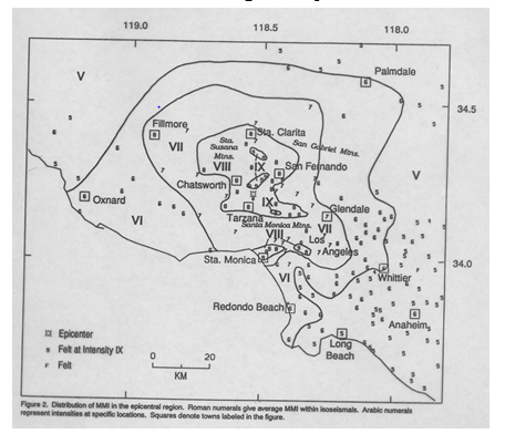
Source: Adapted from Dewey, et al. (1994).
Very short term forewarning of earthquakes can sometimes be initiated by detection of the relatively harmless P-waves that arrive from distant earthquakes a few seconds before the arrival of the damaging S-waves and surface waves. Currently, however, there is no method of advance detection and warning for local earthquakes because these are so close to the impact area that P-waves and S-waves arrive almost simultaneously. Protective measures can be best understood by the common observation that “earthquakes don’t kill people, falling buildings (especially unreinforced masonry buildings) kill people”. Thus, building occupants are advised to shelter in-place under sturdy furniture while the ground is shaking. Those who survive the collapse of their buildings typically attempt to rescue those survivors who remain trapped, but the success of this improvised response depends upon the type of building. Unreinforced masonry buildings are much more likely to collapse, but search and rescue from these structures can be relatively easy. By contrast, steel-reinforced concrete buildings are much less likely to collapse, but search and rescue is extremely difficult unless sophisticated equipment is available to well-trained urban search and rescue teams. Unfortunately, almost all victims will die by the time remote urban search and rescue (USAR) teams arrive because crush injuries usually kill within 24 hours. However, USAR teams take longer than this to mobilize and travel to the incident site. Another problem with earthquakes is that destruction of infrastructure (electric power, fuel, water, wastewater, and telecommunications) impairs emergency response. Consequently, households, businesses, and local governments must be self-sufficient for at least 72 hours until outside assistance can arrive.
Landslides
The term landslide is often used to refer generically to a number of different physical phenomena involving the downward displacement of rock or soil that moves because of gravitational forces. Slides occur because a failure surface is created by two distinct soil strata and the upper stratum is displaced downslope. Some slides are triggered by earthquakes or volcanic eruptions. However, many are caused by heavy rainfall that saturates soil, increasing the weight of the upper surface and lubricating the failure surface. Debris flows have such a high water content distributed throughout the soil mass that they act like a viscous (thick) fluid. Lateral spreads involve the outward movement of material on the sides and downward movement of material on the top of a soil mass. Topples and falls involve rock masses that detach from steep slopes and either tilt or fall free to a lower surface.
Slopes remain stable when shear stress is less than shear strength. Shear stress increases with the steepness of the slope and the weight placed on that slope. Shear strength depends upon the internal cohesion (interlocking or sticking) of soil particles and the internal friction of particles within a soil mass, which is reduced by soil saturation. Thus, landslides are most common in areas having steep slopes composed of susceptible soils types (i.e., ones with low internal cohesion) that are stratified (creating failure surfaces) and saturated with water. Slide probability is commonly increased by four different conditions. The first occurs when slopes have been cleared of vegetation, whereas the second occurs when excavations for houses and roads use the “cut and fill” method on unstable steep slopes. (This technique is used to create a level surface on a slope by cutting soil out of a section of hillside and using it to fill the area below this cut.) The third condition creating landslides occurs when the construction of many buildings and roads significantly increases the weight placed on the slope and the fourth condition occurs when construction of access roads removes support from the foot of the slope.
Landslide risk areas can be mapped by conducting geological surveys to identify areas having slopes with distinct soil strata that are likely to separate when saturated or shaken. Visible cues of imminent slides can also be seen at the head and toe of a potential slide area, which can be monitored to determine whether to take protective actions. These include installing slope drainage systems or retaining walls, and temporarily evacuating or permanently relocating the population at risk.